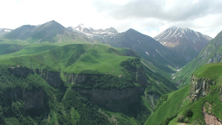
Tskhinvali region is located on the Southern slope of Kavkasioni, between the main watershed range and Northern part of Shida Kartli plain. From the East it is bordered by Alevi range, from the West – by Likhi, Racha and Kedela ranges. Historically the region was under domain of Racha Eristavi (Ruler) and in different historical periods it was part of Kartli and Kakheti kingdoms. Java municipality is situated in the Northern part of region, between municipalities of Tskhinvali and Oni, in the gorge of river Liakhvi. This is a picturesque territory covered with mixed deciduous forests (oak, beech, spruce, pine, fir) and rich with mineral waters. In Soviet period Java was an important recreational area. There were resorts well-known in the whole Soviet Union, like Vezuri, Kodibini, Lese, Bagiati. Java, or ‘Dzau-Suar’, is the most popular in the region spa and health resort. ‘Dzau’ means outlet of the mineral water, while ‘Suar’ means ‘Salty’. Natural outlet of mineral water is situated in the gorge of Didi Liakhvi, on the right bank of the river. The benefits of taking this water were well-known for the local population centuries ago. In 1927 scientists conducted research of Java mineral water and listed features of its use. In several years first sanatoria were built here added later by rest-houses and student camps. Mineral water ‘Dzau Suari’ and ‘Bagiati’ in glass bottles was very popular among customers. Due to the known developments which took place in the 90-ies of the XX c., Java resort area for the time being is no more operable. In 1977, aimed at protection of vegetation typical for the mountains and highlands of Southern slopes of Eastern Kavkasioni, in the upper basin of Liakhvi river, Preserved Territory on the area of 6388 ha was founded. Preserve is covered by forest massifs (beech trees, hornbeam, oak, small amount of spruce, Litvinov birch, 5386 ha) and sub-alpine brushwood, mostly of rhododendron family. There are alpine meadows and cliffs in the upland. Rivers are natural habitat of species from the ‘Red List’ of Georgia – trout. Bird fauna is also rich in the Preserve. From the rare mammal species most noted are included in the ‘Red List’ of Georgia – chamois and brown bear.
1. Ertso Lake (surface area 0,31 sq.km, biggest depth 19 m, elevation above sea level 1710 m, Java municipality, Kudaro gorge, basin of river Kvirila). Ertso Lake is of karst origin. Once in several years water disappears from the Lake. As the scientists presume, disappearance of water is caused by karst cavities existing under the Lake. In winter water freezes. There is no fish in
the Lake.
2. Kudaro gorge is rich with both natural and historical sights, including Kudaro cavernous group of karst caves (5 caves)
having cultural layers and dating back to Acheulian period of 600-400 thousand years. Located near village of Chasavali in Java municipality, on the right bank of river Jejori. Revealed in 1955.
3. Towers of Ermani. Ermani is the highest elevated mountainous village in the region (2000m). Situated in the alpine zone of the gorge of river Ermanistskali. Overall, there are up to 70 defense towers surviving in the region. Most of them were erected in
XVII-XVIIIcc. Like Kudaro gorge, there are several mineral water outlets (presumably, with big content of iron) here as well.
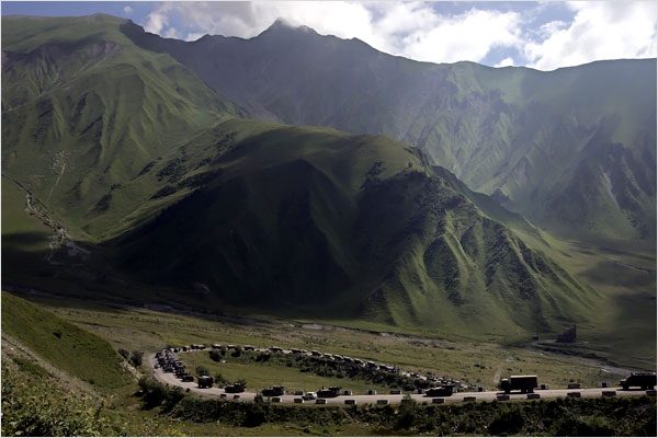
4. Surroundings of the Rocki pass. In 1985 a tunnel of 3730 m was constructed under the pass (2000-2040 m above sea
level) connecting Java with the Russian Federation.
5. Chapel of Cheliati. In XIII-XIV cc. Ossetians transmigrating across Northern Caucasus mountains from houses of worship of
their ancestors brought with them some signs or articles (for example, a stone) and placed them in a small abode in their
new domicile. This spot was a chapel and worship center of their family.
Location: right bank of river Liakhvi (left tributary of river Mtkvari), slope of Java range
Distance: 120 km away from Tbilisi
Sea level: 1040-1120 m
Landscape: mountainous
Climate: middle mountainous (lower belt) climate, winter cold, with snow, mean temperature in January -3,6 degrees; summer moderately warm, mean temperature in August 18,3 degrees centigrade
Average annual precipitation: 966 mm
Average comparative annual humidity: 72%
Duration of annual sunny light: 2200 h.
Natural treatment factors: middle mountain lower belt climate; carbonic acid, chloride-hydro-carbonate, sodium
mineral waters with general mineralization of 0,8-25,8 g/dm3; carbonic acid-chloride, sodium (calcium-magnesium)
mineral waters with general mineralization of 25,4-28 g/dm3; nitrogen carbonate-hydro-carbonatechloride, sodium mineral waters with general mineralization of 1,1-10,3 g/dm3; nitrogen, carbonic acid, hydro-carbonate-chloride, sodium mineral waters with general mineralization of 10,0-11,0 g/dm3; and methane, chloride, calcium-sodium mineral waters with general
mineralization of 10,5-28,5 g/dm3
Types of therapy: balneotherapy (mineral water baths, inhalations, sprinkles, lavage, drinking), passive climate therapy
Diseases for treatment: cardiovascular system pathologies, bronchial asthma and chronic bronchitis, stomach
and duodenum ulcers, chronic gastritis, colitis and enterocolitis, infectious hepatitis, iron-deficit anemia and diseases caused by radioactive exposure
 GEO
GEO ENG
ENG RUS
RUS Forum
Forum