Aarau (German pronunciation: [ˈaːraʊ], locally [ˈɑːræʊ]) is the capital of the northern Swiss canton of Aargau. The city is also the capital of the district ofAarau. It is German-speaking and predominantly Protestant. Aarau is situated on the Swiss plateau, in the valley of the Aare, on the river's right bank, and at the southern foot of the Jura mountains,[3] and is west of Zürich,[4] and 65 kilometres (40 mi) northeast of Bern.[5] The municipality borders directly on the Canton of Solothurn to the west. It is the second-largest city in Aargau after Wettingen. At the beginning of 2010 Rohr became a suburb of Aarau.[6]
The official language of Aarau is (the Swiss variety of Standard) German, but the main spoken language is the local variant of the Alemannic Swiss German dialect.
Geography and geology
The old city of Aarau is situated on a rocky outcrop at a narrowing of the Aare river valley, at the southern foot of the Jura mountains.Newer districts of the city lie to the south and east of the outcrop, as well as higher up the mountain, and in the valley on both sides of the Aare. The neighboring municipalities are Küttigen to the north,Rohr and Buchs to the east, Suhr to the south-east, Unterentfelden to the south, and Eppenberg-Wöschnau andErlinsbach to the west. Aarau and the nearby neighboring municipalities have grown together and now form an interconnected agglomeration. The only exception is Unterentfelden whose settlements are divided from Aarau by the extensive forests of Gönhard and Zelgli. Approximately nine-tenths of the city is south of the Aar, and one tenth is to the north. It has an area, as of 2006, of 8.9 km2 (3.4 sq mi). Of this area, 6.3% is used for agricultural purposes, while 34% is forested. Of the rest of the land, 55.2% is settled (buildings or roads) and the remainder (4.5%) is non-productive (rivers or lakes).The lowest elevation, 365 meters (1,198 ft), is found at the banks of the Aar, and the highest elevation, at 471 meters (1,545 ft), is the Hungerberg on the border with Küttigen.
History
Prehistory
In 1273 the counts of Kyburg died out. Agnes of Kyburg, who had no male relations, sold the family's lands to King Rudolf I von Habsburg. He granted Aarau its city rights in 1283. In the 14th century the city was expanded in two stages, and a second defensive wall was constructed. A deep ditch separated the city from its "suburb;" its location is today marked by a wide street named "Graben" (meaning Ditch).Aarau was founded around AD 1240 by the counts of Kyburg.[4] Aarau is first mentioned in 1248 as Arowe. Around 1250 it was mentioned as Arowa. However the first mention of a city sized settlement was in 1256. The town was ruled from the "Rore" tower, which has been incorporated into the modern city hall.Middle Ages A few artifacts from the Neolithic period were found in Aarau. Near the location of the present train station, the ruins of a settlement from the Bronze Age (about 1000 BC) have been excavated. The Roman road between Salodurum (Solothurn) and Vindonissa passed through the area, along the route now covered by the Bahnhofstrasse. In 1976 divers in the Aare found part of a seven-meter wide wooden bridge from the late Roman times.
In 1415 Bern invaded lower Aargau with the help of Solothurn. Aarau capitulated after a short resistance, and was forced to swear allegiance to the new rulers.[5] In the 16th century, the rights of the lower classes were abolished. In March 1528 the citizens of Aarau allowed the introduction of Protestantism at the urging of the Bernese. A growth in population during the 16th Century led to taller buildings and denser construction methods. Early forms of industry developed at this time; however, unlike in other cities, no guilds were formed in Aarau.
On 11 August 1712, the Peace of Aarau was signed into effect. This granted each canton the right to choose their own religion thereby ending Catholicism's control.[11][12]Starting in the early 18th century, the textile industry was established in Aarau. German immigration contributed to the city's favorable conditions, in that they introduced the cotton and silk factories. These highly educated immigrants were also responsible for educational reform and the enlightened, revolutionary spirit that developed in Aarau.
1798: Capital of the Helvetic Republic[edit]
On 27 December 1797, the last Tagsatzung of the Old Swiss Confederacy was held in Aarau. Two weeks later a French envoy continued to foment the revolutionary opinions of the city. The contrast between a high level of education and a low level of political rights was particularly great in Aarau, and the city refused to send troops to defend the Bernese border. By Mid-March 1798 Aarau was occupied by French troops.
On 22 March 1798 Aarau was declared the capital of the Helvetic Republic.[7] It is therefore the first capital of a unified Switzerland. Parliament met in the city hall. On 20 September, the capital was moved to Lucerne.
Aarau as canton capital
In 1803, Napoleon ordered the fusion of the cantons of Aargau, Baden and Fricktal. Aarau was declared the capital of the new, enlarged canton of Aargau. In 1820 the city wall was torn down, with the exception of the individual towers and gates, and the defensive ditches were filled in.
The wooden bridge, dating from the Middle Ages, across the Aare was destroyed by floods three times in thirty years, and was replaced with a steel suspension bridge in 1851. This was replaced by a concrete bridge in 1952. The city was linked up to the Swiss Central Railway in 1856.
The textile industry in Aarau broke down in about 1850 because of the protectionist tariff policies of neighboring states. Other industries had developed by that time to replace it, including the production of mathematical instruments, shoes and cement. Beginning in 1900, numerous electrical enterprises developed. By the 1960s, more citizens worked in service industries or for the canton-level government than in manufacturing. During the 1980s many of the industries left Aarau completely.
In 1802 the Canton School was established; it was the first non-parochial high school in Switzerland. It developed a good reputation, and was home to Nobel Prize winnersAlbert Einstein, Paul Karrer, and Werner Arber, as well as several Swiss politicians and authors.
The purchase of a manuscript collection in 1803 laid the foundation for what would become the Cantonal Library, which contains a Bible annotated by Huldrych Zwingli, along with the manuscripts and incunabula. More newspapers developed in the city, maintaining the revolutionary atmosphere of Aarau. Beginning in 1820, Aarau has been a refuge for political refugees.
The urban educational and cultural opportunities of Aarau were extended through numerous new institutions. A Theatre and Concert Hall was constructed in 1883, which was renovated and expanded in 1995–96. The Aargau Nature Museum opened in 1922. A former cloth warehouse was converted into a small theatre in 1974, and the alternative culture center KIFF (Culture in the fodder factory) was established in a former animal fodder factory.
Origin of the name
The earliest use of the place name was in 1248 (in the form Arowe), and probably referred to the settlement in the area before the founding of the city. It comes, along with the name of the River Aare (which was called Arula, Arola, and Araris in early times), from the German Au, meaningfloodplain.
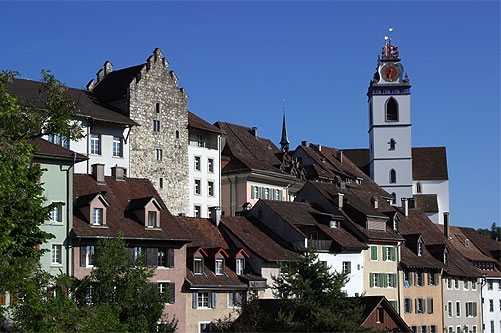
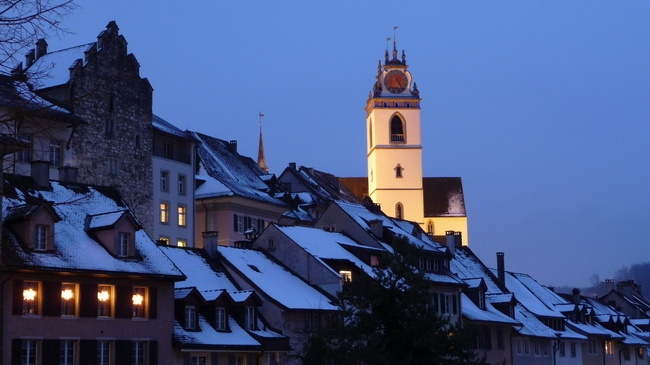
Old town
The buildings in the old city originate, on the whole, from building projects during the 16th century, when nearly all the Middle Age period buildings were replaced or expanded. The architectural development of the city ended in the 18th century, when the city began to expand beyond its (still existing) wall. Most of the buildings in the "suburb" date from this time.The historic old town forms an irregular square, consisting of four parts (called Stöcke). To the south lies the Laurenzenvorstadt, that is, the part of the town formerly outside the city wall. One characteristic of the city is its painted gables, for which Aarau is sometimes called the "City of beautiful Gables". The old town, Laurenzenvorstadt, government building, cantonal library, state archive and art museum are all listed as heritage sites of national significance.
The "Schlössli" (small Castle), Rore Tower and the upper gate tower have remained nearly unchanged since the 13th century. The "Schlössli" is the oldest building in the city. It was already founded at the time of the establishment of the city shortly after 1200; the exact date is not known. City hall was built around Rore Tower in 1515.
The town church was built between 1471 and 1478. During the Reformation, in 1528, its twelve altars and accompanying pictures were destroyed. The "Justice fountain" (Gerechtskeitbrunnen) was built in 1634, and is made of French limestone; it includes a statue of Lady Justice made of sandstone, hence the name. It was originally in the street in front of city hall, but was moved to its present location in front of the town church in 1905 due to increased traffic.The upper gate tower stands beside the southern gate in the city wall, along the road to Lucerne and Bern. The jail has been housed in it since the Middle Ages. A Carillon was installed in the tower in the middle of the 20th century, the bells for which were provided by the centuries-old bell manufacturers of Aarau.
 GEO
GEO ENG
ENG RUS
RUS Forum
Forum