Historical and geographic area of Georgia - Okriba – covers today’s territory of Tkibuli municipality. There are a lot of natural
quarries mining chalcedony, barite, quartz sand, marble, basalt, agate, fireproof clays used for cement production, teshenit… Administrative center, town of Tkibuli, is known as the town of coal miners. Coal mining has been under way in the environs of Tkibuli
since mid-XIX century. But archeological excavations show that ore was mined here as early as II millennium BC. The main river in Okriba is river Tskaltsitela. The name was assigned because of reddish color of water (‘Tsitela’ means ‘Red’ in Georgian) which it acquires at its rise by washing clays containing iron rust. River Tskaltsitela rises from the South slopes of Nakerala range, it crosses the whole territory of Okriba and at the end of its flow it merges with river Kvirila. The relief of its riverbed creates ideal living conditions for various species of fish. River is rich with barbell, barbus capito, minnow, bullhead, and near confluence there are also species of cat-fish and perch. There are some important resort areas on the territory of municipality, including, but not limited to, Satsire, recreational resort for children with therapeutic properties against allergy, bronchitis, pneumonia, inherent heart disease and bronchial asthma, supported by balneotherapy of the resort and application of nitric, slightly sulfide, hydro-carbonate, magnesium-calcium containing
mineral waters used for curing disorders musculoskeletal system, peripheral nervous system, cardiovascular system, gynecological
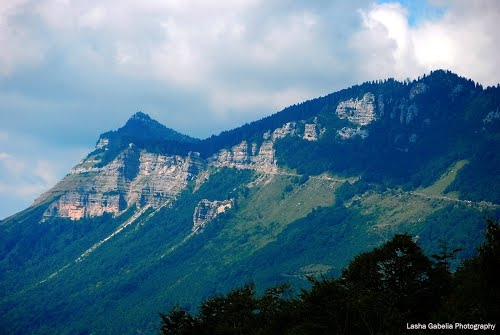
profile diseases. On the Western slope of Nakerala range, at 1350 m above sea level, fantastic panoramic view on the whole
town of Tkibuli opens up. In the 80-ies of the XX century holiday center of federal importance operated on the mountain and was connected with town by cableway. The climate of Tskhrajvari and nearby cave are used for healing of many diseases.
Location: Southern slope of Nakerala range
Distance: 50 km from Kutaisi, 230 km from Tbilisi.
Sea level: 1350 m
Landscape: hillocky
Climate: middle mountain (lower belt) climate, winter cold, with snow, mean temperature in January 4,8 degrees centigrade; summer moderately warm, mean temperature in August 18,5 degrees centigrade
Average annual precipitation: 1400 mm
Average comparative annual humidity: 74%
Duration of annual sunny light: 1700-1800 h.
Natural treatment factors: climate of middle mountain lower belt, karst caves
Types of therapy: passive climate therapy
Diseases for treatment: cardiovascular pathologies, nervous system functional disorders, iron deficit anemia

 GEO
GEO ENG
ENG RUS
RUS Forum
Forum